
Before modern roads existed, before there were wheels or horses, the Inca Empire had already built one of the most sophisticated road systems the ancient world had ever known. Thousands of kilometers of stone trails crossed coastal deserts, tropical jungles, frozen highlands, and deep canyons, connecting villages, cities, sanctuaries, and administrative centers from Colombia to northern Argentina and Chile.
That network was called Qhapaq Ñan, which in Quechua means “the lord’s road” or “main road.” And the Inca Trail that thousands of trekkers hike each year to Machu Picchu is just one section of it. A famous, spectacular stretch full of history, but only a fragment of something much larger and even more extraordinary.
If you are going to hike the Inca Trail, or you simply want to understand what you are seeing when you walk it, this guide tells the real story behind the road network that forever changed the face of a continent.
What the qhapaq ñan was and how long it really was
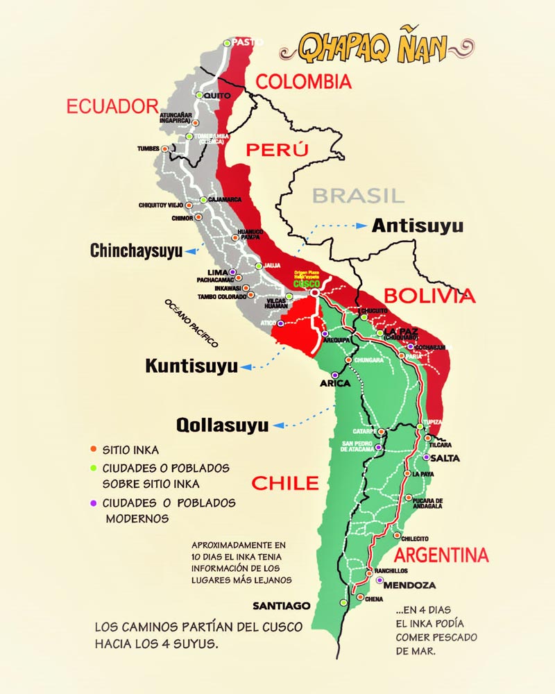
The Qhapaq Ñan was not a single road but an integrated network of routes that, at the height of its expansion, reached approximately 30,000 kilometers in total length. To understand the scale of that number, consider that the distance from Earth to the Moon is about 384,000 kilometers: the Inca road system represented nearly one-twelfth of that distance, built by hand, without machinery, across one of the most challenging landscapes on the planet.
The network had two main arteries. The first ran along the Pacific coast, from the north of what is now Ecuador to central Chile. The second, and most important, crossed the highlands from Colombia to northwestern Argentina. These two trunk routes were connected by hundreds of transverse roads that descended from the mountains to the sea or extended into the Amazon jungle.
In 2014, UNESCO declared the Qhapaq Ñan a World Heritage Site, recognizing its exceptional value as an engineering achievement, as shared cultural heritage for six countries Peru, Bolivia, Ecuador, Colombia, Argentina, and Chile and as a living testimony to the civilization that built it.
When and how the inca road network was built
The Incas did not build the Qhapaq Ñan from scratch or in a single generation. For centuries, the Andean regions had already been crossed by earlier cultures Wari, Tiwanaku, and Chimú which left behind their own trails and trade routes. What the Incas did was something far more ambitious: they took those scattered fragments, expanded them, paved them, standardized them, and wove them into a coherent and functional system in service of a growing empire.
The most intense period of construction coincided with the expansion of the Tahuantinsuyo, the name the Incas gave to their own empire, meaning “the four regions of the world.” From the 14th century to the early 16th century, each newly conquered territory was connected to the main network through the construction of new road sections. In that sense, the Qhapaq Ñan was both a tool of conquest and a tool of government: without roads, there was no Empire.
The labor force that built these roads was not enslaved in the Western sense of the term. It functioned through the mit’a, a system of mandatory communal labor in which each community had to provide a quota of work to the Inca state in exchange for protection, food redistribution, and participation in the Empire’s projects. It was an economy of reciprocity, not exploitation, although the working conditions at extreme altitude or in hostile terrain were clearly harsh.
What inca road engineering was like
What surprises people most when they hike the Inca Trail is not the distance or the altitude: it is the quality of the construction after five centuries of use, rain, earthquakes, and abandonment. The best-preserved sections reveal an engineering tradition that has nothing to envy the Romans in Europe or the Persians in Asia.
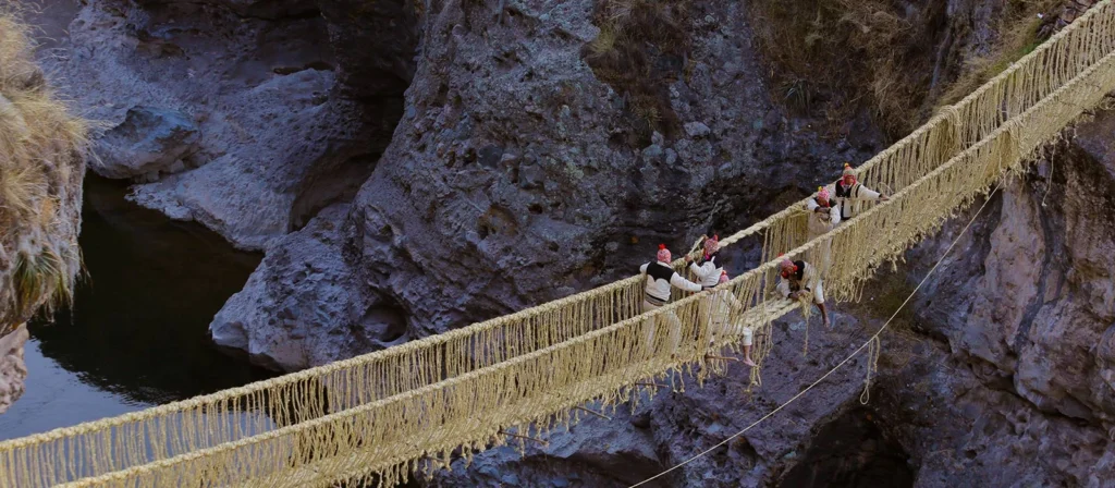
Inca roads in mountainous terrain were paved with stone slabs fitted together without mortar, following the same technique they used to build their structures. In steeper areas, the road became stairways with steps carved directly into the rock or built with perfectly leveled blocks. At river crossings and ravines, Inca engineers built suspension bridges made of braided plant fiber, mainly maguey and ichu grass, strong enough to support the passage of entire armies and renewed every year through communal labor.
Along the desert coast, where stone was not available, roads were built with adobe walls on both sides to mark the route in the sand. In the jungle, elevated platforms were installed over the mud to keep the road from sinking during the rains. Each environment received a specific solution, designed by engineers who knew the territory they were taming perfectly.
Throughout the network there were also tambos, a kind of waystation or rest stop spaced about a day’s walk apart. At the tambos, travelers and imperial officials could rest, eat, and resupply. Some tambos were small and simple; others, such as the one at Raqchi in Cusco, were large architectural complexes with storage areas, kitchens, and spaces to house hundreds of people.
What the inca trail was used for: much more than a trekking route
The Qhapaq Ñan was not a tourist trail or a route for the everyday use of the general population. It was the logistical, military, administrative, and religious backbone of the largest empire in pre-Columbian America. Its functions were many, and all of them were essential to the operation of the Tahuantinsuyo.
Army movement was perhaps its most immediate function. An Inca army could move along the Qhapaq Ñan at a speed that would surprise any modern military strategist: troops are estimated to have covered between 30 and 40 kilometers a day on these roads, allowing forces to move from Cusco to the farthest reaches of the Empire in weeks, not months.
The chasqui system was the Empire’s communications network. The chasquis were young messengers trained from childhood to run long distances at great speed and high altitude. They were stationed at relay posts just a few kilometers apart throughout the road network and passed along messages orally or in the form of quipus, the Inca system of knotted record-keeping, from one to another in an unbroken chain. It is estimated that a message could cover the 2,000 kilometers between Cusco and Quito in about five days. In terms of communication speed, that had no equivalent in the ancient world.
The movement of goods was another central function. Llamas loaded with agricultural products, textiles, minerals, and other resources traveled constantly along the network, redistributing surpluses from producing areas to storage centers and from there to the communities that needed them. The qollqas, the imperial storehouses distributed along the Qhapaq Ñan, were the nodes of this continent-scale redistribution system.
The religious function of the road was equally important. The Empire’s great sanctuaries including the Temple of the Sun on the Island of the Sun in Lake Titicaca, the Coricancha in Cusco, and the oracle of Pachacamac on the coast were connected by the Qhapaq Ñan. Processions, pilgrimages, and ritual sacrifices followed these sacred routes, which the Incas regarded not only as physical roads but as lines of energy linking the places of power in the Andean world.
The spanish conquest and the abandonment of the road network
When Francisco Pizarro and his men arrived in the Andean region in 1532, they were astonished by the quality and extent of the Inca roads. In fact, the speed with which the conquerors were able to move through such a vast and difficult territory was due in large part to the Qhapaq Ñan itself: the Spanish used the Inca road network to conquer the Empire that had built it.
With the collapse of the Tahuantinsuyo, the system that kept the roads alive the mit’a, the tambos, the chasquis, and the imperial redistribution system disappeared. Without maintenance, the most fragile sections were swallowed by vegetation, eroded by rain, or simply abandoned because the new colonial routes followed different alignments. Many segments of the Qhapaq Ñan were buried beneath centuries of earth, overgrowth, and oblivion.
Paradoxically, that abandonment also helped preserve some of its most beautiful stretches. The segment of the Inca Trail that runs from Kilometer 82 to Machu Picchu remained relatively intact partly because the jungle protected it from looting and partly because Machu Picchu itself fell into obscurity for the outside world until 1911, when Hiram Bingham reintroduced it to the international community.
The inca trail today: living heritage and a trekking destination
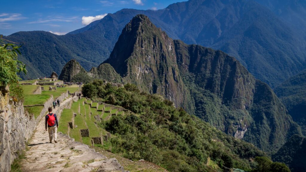
Today, the section of the Inca Trail that connects the Sacred Valley with Machu Picchu is one of the most famous and sought-after trekking routes in the world. Its approximately 43 kilometers, spread over four days of hiking, cross three mountain passes the highest at 4,215 meters above sea level several secondary archaeological sites, cloud forest, and landscapes that change dramatically from one day to the next.
Access is regulated by Peru’s Ministry of Culture, which limits the number of people who can hike the Inca Trail each day to a maximum of 500, including guides, porters, and cooks. This restriction is intended to protect the trail from the deterioration that uncontrolled mass tourism would cause. As a direct result, permits sell out months in advance, and early planning is not optional if this trek is on your list.
Beyond the tourist section to Machu Picchu, the Qhapaq Ñan continues to be researched, restored, and rediscovered in stretches across its full extent by six countries. Andean communities living alongside the roads keep them alive, in some cases as routes for everyday use, in others as community-based tourism trails that allow travelers to experience the Andean world much more deeply than through a bus window.
Walking even just one section of the Inca Trail means stepping onto one of the most extraordinary works humanity has ever built. It is not just a mountain trail: it is the backbone of a civilization.
Do you want to hike the Inca Trail and arrive at Machu Picchu through the Sun Gate? At Incredible Peru Tours, we handle the permits, organize a team of certified guides and porters, and make sure every day of the trek becomes an experience you will remember forever.


