

Tambomachay is an Inca archaeological site located about 8 kilometers northeast of Cusco’s Plaza de Armas, right along the road that leads to Pisac. It’s one of the most interesting places around the city thanks to its hydraulic system of channels, fountains, and small waterfalls that still carry a steady flow. Its likely function was tied to ceremonies involving water, and because it sits so close to Puka Pukara, it’s usually visited on the same route. To enter you need the Cusco Tourist Ticket, since there normally isn’t an individual admission for this site.
What is Tambomachay?
Tambomachay is an Inca archaeological complex on the outskirts of the city of Cusco, set on a mountain slope at a higher elevation than the historic center. The main sector open to the public brings together stone walls, terraces, niches, channels, aqueducts, and fountains that draw on water from a nearby spring.
The place is known for the precision with which the Incas moved water through the different levels of the site. Although guidebooks often describe it as a resting spot or a bath of the Inca, that definition falls short. Its hydraulic and architectural features connect it above all to a ceremonial function and to the management of water within the Cusco landscape.
What does Tambomachay mean?
The origin of the name Tambomachay has several interpretations. One common explanation links the word tampu to a place of lodging, a stop, or a rest point along the Inca roads. Machay, for its part, can be translated as cave, grotto, or hollow.
These references help explain why the name has been associated both with a possible waystation and with the natural formations of the surroundings. Even so, there is no single definitive accepted translation for the full term, so these versions are best presented as linguistic interpretations rather than absolute certainties.
Tambomachay or Tampumachay
Tambomachay and Tampumachay refer to the same archaeological site. The first form is the one most used on tourist signage, in travel publications, and in internet searches, which is why it’s used as the primary variant in this guide.
Tampumachay shows up often when people look for a spelling closer to the Quechua origin of the name. Both are valid, but they don’t point to different sites or to separate sectors of the complex.
Why is it known as the Bath of the Inca?
The popular name “Bath of the Inca” comes from the fountains and the water that flows constantly through the main sector of Tambomachay. The arrangement of the channels and small waterfalls gave rise to the idea that the Inca may have used this place to bathe or rest.
It has never been proven that it worked as a bath in the modern sense. The most widely held archaeological interpretation is that the water may have served a ritual purpose, tied to ceremonies of purification, fertility, and renewal. So “Bath of the Inca” should be understood as a traditional name, not as a conclusively proven function.
History of Tambomachay
Tambomachay was built during the Inca period and formed part of the ceremonial territory surrounding the ancient imperial capital. Its location, outside the urban core but close to the access routes into Cusco, made it possible to bring architecture, water, and terrain together in a single site.
The exact history of the site and all of its functions are still not fully established. The walls, channels, and fountains are visible archaeological evidence; the explanations about specific ceremonies, elite retreats, or road surveillance, on the other hand, are interpretations that should be read with caution.
Origin of the Inca archaeological complex
The Tambomachay complex was raised by taking advantage of the natural springs, the slope of the mountain, and the conditions of the terrain. The Inca builders adapted the walls and conduits to the relief in order to carry water down to the fountains on the lower levels.
This integration of architecture, water, and landscape reflects careful planning. It wasn’t just a matter of moving water: the layout of the channels, the built spaces, and the presence of high-status architectural elements suggest the place held particular importance within the area around Cusco.
The importance of Tambomachay within the Antisuyo
Tambomachay sat near one of the ancient roads linked to the Antisuyo, one of the four territorial divisions of the Tahuantinsuyo. This area connected Cusco with territories on the eastern slopes, making it a significant route for travel and imperial organization.
Its location may have given it ceremonial, territorial, and strategic importance. Its closeness to Puka Pukara has reinforced interpretations about the movement and control of those arriving in or leaving the city, though the site shouldn’t be defined solely by a surveillance function.
What was Tambomachay used for?
Tambomachay probably had more than one function. The main interpretations connect it to water worship, purification ceremonies, rest for the Inca elite, and the control of routes near Cusco.
The available evidence makes it clear that water was a central element in the design of the complex. The specific activities carried out there, though, aren’t fully documented, so it’s more accurate to speak of archaeological and historical possibilities.
Water worship and Inca ceremonies
The system of fountains and channels connects Tambomachay to the religious importance of water within the Inca worldview. Water was an element linked to fertility, life, purification, and the renewal of natural cycles.
The steady channeling of the resource from a spring toward built fountains may have been part of ritual ceremonies. The orderly handling of the water doesn’t appear accidental, and it helps explain why Tambomachay is considered primarily a ceremonial space.
A resting place for the Inca elite
A traditional interpretation holds that Tambomachay may have worked as a resting place for the Inca and his retinue while traveling the routes near the capital. This idea ties in with the possible meaning of tampu as a stop or lodging.
The presence of water, built areas, and a setting removed from the urban center makes this reading plausible. Even so, the explanation doesn’t on its own define the complete function of the complex, since its fountains and ceremonial elements point to a broader use.
Was Tambomachay a temple or a bathing site?
Tambomachay is considered primarily a ceremonial space connected to water. Its fountains and channels don’t allow us to claim it was an enclosed temple like other Inca structures, but they do indicate the place may have been intended for ritual practices.
The term “bathing site” comes up frequently in tourist descriptions because of the fountains and waterfalls. That doesn’t mean Tambomachay had the same functions as a modern bathing resort, or that it was used only for bathing.
Possible connection to road surveillance
Tambomachay’s position and its closeness to Puka Pukara have given rise to interpretations about the control of the access roads into Cusco. Puka Pukara is usually associated with surveillance, temporary lodging, or traffic control in this area.
Tambomachay may have been tied to those dynamics by proximity and by its location beside an important route. Even so, it isn’t accurate to define it exclusively as a military or defensive structure, since its water system and architectural features point to other functions.
Architecture of Tambomachay
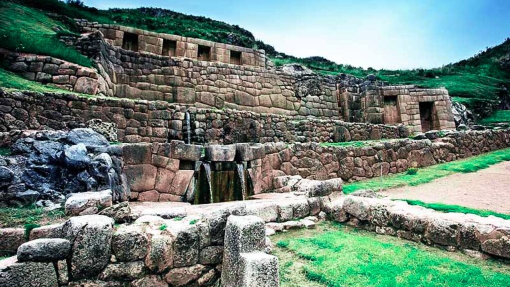
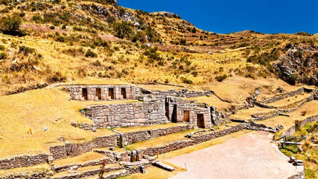
Tambomachay’s architecture adapts to the mountain slope through walls, terraces, platforms, entryways, niches, channels, and fountains. The best-known sector concentrates the hydraulic structures that receive the water and distribute it across different levels.
The site reveals precise planning, especially in how the slopes were handled and in the stonework needed to keep the water flowing. Some walls feature well-cut blocks, while other sectors use a simpler technique adapted to the hillside.
Tambomachay’s hydraulic system
The main architectural feature of Tambomachay is its network of channels and aqueducts. This system carries water from a spring toward the fountains visible in the complex, making use of the natural incline of the terrain.
The flow stays continuous under normal conditions, which lets you appreciate how effective Inca water engineering was. That said, the exact location of the water’s full source and the complete path of the conduits shouldn’t be presented as confirmed facts without specific technical studies.
Fountains and waterfalls
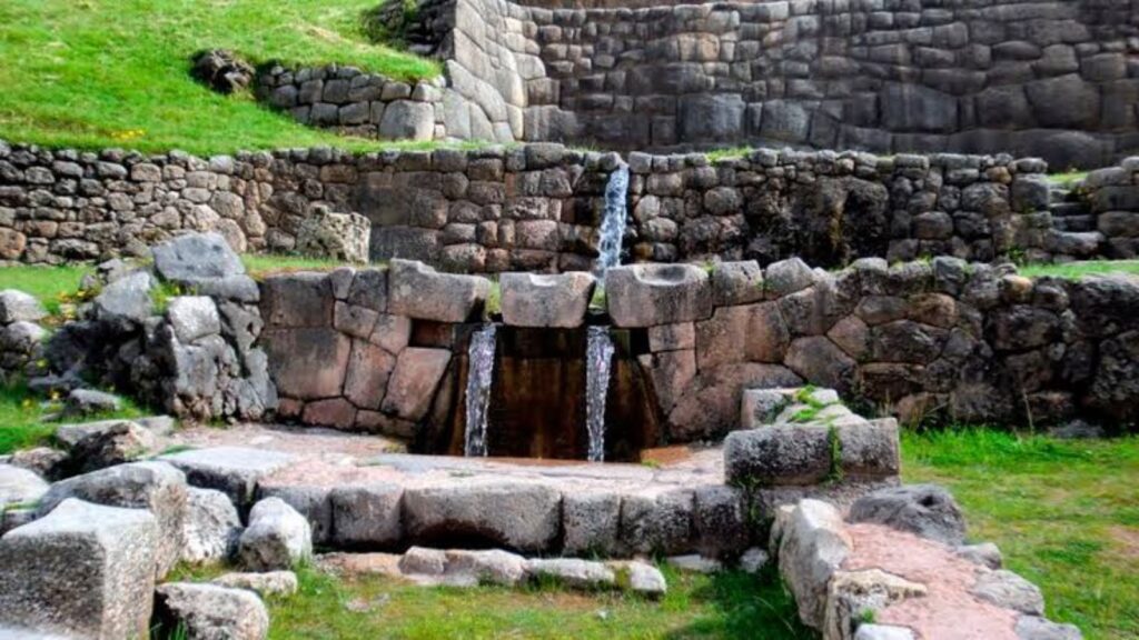
The stepped fountains are the most recognizable visual feature of Tambomachay. The water falls through small conduits and spreads across levels built of stone, creating a path that follows the shape of the wall.
The layout demonstrates knowledge of water channeling, gradients, and the use of natural springs. For visitors, watching the water in motion helps make clear that hydraulic design was a central part of the site rather than a minor detail.
Stone walls and terraces
Tambomachay features walls and terraces built along the hillside. These structures made it possible to stabilize the ground, organize the levels of the complex, and create spaces connected to the fountains and entryways.
Some sectors show carefully cut and fitted stones, especially near the main areas. In other zones the work is simpler, adapted to a retaining function and to the natural characteristics of the site.
Niches and trapezoidal entryways
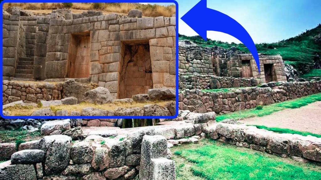
On the upper walls you’ll see niches and trapezoidal entryways, elements common in Inca architecture. These openings didn’t just bring visual order to the structures; they could also respond to functional or ceremonial needs.
The presence of these features suggests that certain areas held greater importance within the complex. Although the precise use of each niche isn’t known, their placement beside the fountains and finished walls reinforces the ceremonial interpretation of Tambomachay.
The double-jamb doorway
A double-jamb doorway has a stepped frame made up of two levels. This type of entrance is identified by the repetition of the trapezoidal outline around the main opening.
In several Inca constructions, double-jamb doorways are associated with spaces considered important. At Tambomachay, this architectural detail helps you recognize that certain enclosures weren’t areas of common use, though their exact function remains a matter of interpretation.
What to see during your visit to Tambomachay
During your visit to Tambomachay, the route focuses on the open sector around the fountains, walls, and channels. It’s a site of manageable size, so it’s worth moving slowly and taking in the details of the hydraulic system.
The appeal doesn’t depend on long walks inside the site but on understanding how the water, the structures, and the slope work together as a whole. A guide can help you tell the visible elements apart from the traditional interpretations of the place.
The ceremonial fountains
The fountains are the main feature of Tambomachay. They’re built into the stone walls and receive water from the upper channels, forming small waterfalls that stay active for much of the year.
The sound and constant movement of the water are a meaningful part of the visit. From the permitted areas, you can see how the fountains were arranged across levels and how the water follows a carefully calculated path.
The carved channels and aqueducts
You can spot carved conduits and channels that distribute water through the different levels of the complex. Some are discreetly built into the walls, so it’s worth looking closely before moving on.
The precision of the hydraulic system shows in the continuity of the flow and in the use of the gradient. There’s no need to credit unproven mechanisms to appreciate the technical skill it took to move water permanently across a hillside.
Terraces, niches, and Inca walls
The terraces, niches, and walls surround the fountains and shape the visible route. These elements let you see how the construction adapted to the mountain, combining retaining sectors with more elaborate spaces.
The different types of stone and finishes show that not every wall served the same purpose. Noticing these details helps you avoid a rushed visit focused only on the waterfalls.
The Andean landscape surrounding Tambomachay
The site is surrounded by hills, grasslands, and mountains that contrast with Cusco’s urban area. From the open sectors, you can take in the elevated position of the complex and the direct relationship between the construction and the natural springs of the surroundings.
This landscape helps you understand why water played a decisive role in the choice of location. The architecture wasn’t set down in isolation: it was designed around the slope, the springs, and the routes that connected this area with the city.
The relationship between Tambomachay and Puka Pukara
Tambomachay and Puka Pukara are very close to each other and are usually visited on the same route. The short distance between them makes them easy to combine, whether by taxi, tourist transportation, or an organized tour.
Historically, it has been suggested that Puka Pukara may have carried out control, surveillance, or lodging functions tied to the activities at Tambomachay. This relationship is an interpretation based on proximity and on the context of the Inca roads, not a fully proven function for either site.
Where is Tambomachay?
Tambomachay is roughly 8 kilometers northeast of the city of Cusco, beside the highway that leads to Pisac. From the Plaza de Armas, the drive usually takes 25 to 40 minutes, depending on traffic and the type of transportation.
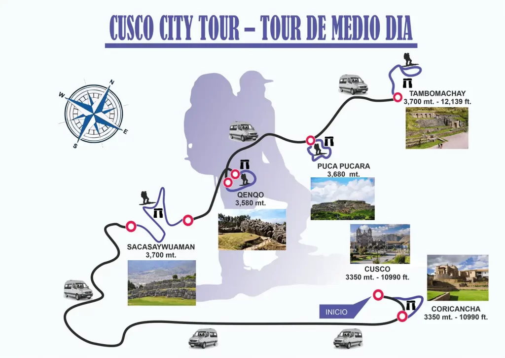
The complex sits in an area higher than the historic center, near other frequently visited archaeological parks such as Puka Pukara, Qenqo, and Sacsayhuaman. Using the Plaza de Armas as a reference point is useful for calculating departure times and organizing your route.
What is the altitude of Tambomachay?
Tambomachay sits at an approximate altitude of 3,700 m.a.s.l. This figure can vary slightly depending on the exact measurement point within the complex and the mapping sources consulted.
The site is higher than Cusco’s historic center. If you’ve just arrived in the city, it’s best to acclimatize, stay hydrated, and avoid demanding walks before visiting high-elevation areas. Anyone with a headache, dizziness, or shortness of breath should ease up on the effort and prioritize rest.
How far is Tambomachay from Puka Pukara?
Tambomachay and Puka Pukara are separated by a short distance, a few minutes by road or on foot depending on your starting point and the entrance used. That’s why both sites are typically included in the same itinerary.
The combination works well for travelers with limited time, since it lets you see two nearby complexes without returning to downtown Cusco in between. Keep the altitude in mind and walk at an easy pace if you decide to cover the stretch on foot.
Tambomachay visiting hours
Tambomachay’s hours can change due to conservation work, Ministry of Culture regulations, holidays, or operational conditions. Before you travel, check the current schedule directly with the site administration, COSITUC, or an official tourist information point in Cusco.
As a planning reference, the archaeological parks near Cusco generally operate during daytime hours. It’s not a good idea to show up late in the afternoon without confirming the last admission time, especially if your visit depends on public transportation or on a route covering several attractions.
What is the best time of day to visit Tambomachay?
Early morning is a good choice if you prefer milder temperatures, good light, and fewer visitors. It also lets you walk the site without rushing and combine it afterward with Puka Pukara or other nearby places.
Afternoon is a common alternative when Tambomachay is part of a route through Cusco’s archaeological parks. At that hour there may be more tour groups, and the temperature tends to drop quickly, so it’s worth bringing a warm layer.
How much time do you need to visit Tambomachay?
An individual visit to Tambomachay usually takes 30 to 45 minutes in the main open sector. That’s enough time to take in the fountains, channels, walls, and landscape without needing a long walk.
If you’re traveling with a guide, taking photos, or combining the visit with Puka Pukara, plan on one to one and a half hours for both places. During the rainy season, wet surfaces or the movement of groups can make the route take a little longer.
Admission to Tambomachay and the Cusco Tourist Ticket
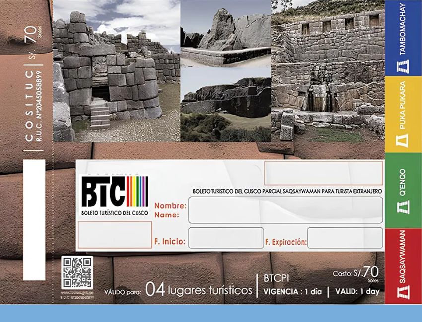
Tambomachay is one of the attractions included in the Cusco Tourist Ticket. It normally doesn’t have a separate individual admission, so you’ll need to buy a ticket option that covers the archaeological parks near the city.
Rates, validity periods, discount conditions, and points of sale can change. Before booking a trip, check the official COSITUC information, the entity in charge of the Cusco Tourist Ticket.
Admission price for Tambomachay
It isn’t advisable to treat an old rate as the current admission price for Tambomachay, because access depends on the Cusco Tourist Ticket and its conditions can be updated. COSITUC usually distinguishes between foreign visitors, nationals, and students, where applicable.
Since the ticket covers several attractions rather than exclusive admission to Tambomachay, the final cost depends on the option you choose. Check the official rate list before buying and confirm which documents are required to qualify for a national or student rate.
Which ticket do you need to visit Tambomachay?
To visit Tambomachay, travelers generally use the Partial Tourist Ticket for the archaeological parks near Cusco or the Full Tourist Ticket. The partial ticket is designed for those who want to tour the sites on the circuit near the city within a limited validity period.
The Full Tourist Ticket covers a wider group of cultural and archaeological attractions in Cusco and the Sacred Valley. The exact validity, the sites included, and any restrictions should be confirmed on the official COSITUC rate list before you finalize your itinerary.
Where to buy the ticket for Tambomachay
The Cusco Tourist Ticket is sold at official points of sale authorized by COSITUC and, depending on availability, at some entrances to the included attractions. Confirm before heading out whether the booth at Tambomachay will be selling tickets on the day of your visit.
It’s also a good idea to ask at Cusco’s official tourist information offices about the current points of sale. If an official online sales option exists, look for it only through COSITUC channels to avoid paying unauthorized intermediaries.
How to get to Tambomachay from Cusco
From Cusco’s historic center, you can reach Tambomachay by taxi, public transportation, on foot, or on an organized tour. A taxi offers more comfort and speed; public transportation is cheaper, while walking requires good acclimatization given the distance and the elevation gain.
The best option depends on your time, budget, and fitness. If you plan to visit several archaeological parks in a single afternoon, an organized service usually simplifies the logistics and cuts down the time spent looking for transportation between sites.
How to get to Tambomachay by taxi
A taxi is a fast option from the Plaza de Armas or from any lodging in the historic center. The ride usually takes 25 to 40 minutes, depending on traffic, the time of day, and your starting point.
Agree on the price before getting in and ask whether the driver will wait during your visit or only handle the trip out. Use formal transportation, arranged through your lodging or booked with a trusted driver, especially if you plan to head back when fewer vehicles are around.
How to get to Tambomachay by public transportation
Some vehicles running along the highway toward Pisac pass near Tambomachay. This option is usually cheaper than a taxi, but it calls for more flexibility and may involve walking from the stop to the entrance.
Confirm the boarding point, the right stop, the fare, and current schedules locally before you head out. Routes and frequencies can vary, so it’s best not to rely on an old reference found online.
How to walk to Tambomachay
The walk from downtown Cusco to Tambomachay is long, uphill, and demanding because of the altitude. It can take several hours, depending on your pace, the route you choose, and any stops at other archaeological sites.
It’s mainly an option for travelers who are already acclimatized, have hiking experience, and are wearing proper footwear. Bring water, sunscreen, layered clothing, and an offline map. It isn’t a good choice for your first day in Cusco or for anyone with symptoms of altitude sickness.
How to visit Tambomachay on an organized tour
Organized tours usually combine Tambomachay with Coricancha, Sacsayhuaman, Qenqo, and Puka Pukara. This option normally includes tourist transportation, a planned route, and professional guiding, which helps if you want to see several places in a short time.
If you’d rather have a coordinated departure with set times, the Cusco City Tour brings these archaeological parks together in a single afternoon. Before booking, confirm which admissions are included and whether you need to buy the Tourist Ticket separately.
Best time of year to visit Tambomachay
Tambomachay can be visited year-round, but conditions change between the dry season and the rainy season in Cusco. Your choice affects the state of the paths, visibility, the color of the landscape, the temperature, and the number of visitors.
The dry season generally makes outdoor touring easier, while the rainy season offers a greener setting but calls for more preparation. In both cases, layered clothing helps with the temperature swings typical of the high country around Cusco.
Visiting Tambomachay during the dry season
During the dry season, which generally runs from April to October, there is less rain and more comfortable conditions for touring Tambomachay. The trails and walkways tend to be less damp, which makes the visit easier.
The downside is heavier tourist traffic, especially from June to August. Days can feel mild in the sun, but mornings and evenings are cold. Bring sunscreen, a hat, and a jacket for when the temperature drops.
Visiting Tambomachay during the rainy season
During the rainy season, generally from November to March, the landscape around Tambomachay can look greener. Rainfall tends to concentrate in the afternoon, though the weather can shift suddenly.
It’s worth bringing a rain jacket, shoes with good grip, and protection for cameras or phones. Surfaces can be wet and slippery, so it’s better to walk slowly and stay within the marked visitor areas.
Tips for visiting Tambomachay
A comfortable visit to Tambomachay depends more on good preparation than on complex planning. The altitude, sun exposure, and weather changes are all worth considering before you leave Cusco.
Always respect the designated areas and avoid turning the visit into a rushed walk. The complex is small, but its fountains and architectural details come through better when you take your time and follow the conservation rules.
What to bring to Tambomachay
Bring your ID and your Cusco Tourist Ticket, since they may be requested at the entrance. It’s also a good idea to carry water, sunscreen, a hat, layered clothing, and shoes with good grip.
During the rainy season, add a rain jacket and a cover to protect your devices. The visit is short, but the altitude and the weather can make an unprepared outing uncomfortable.
What you can’t do at Tambomachay
Don’t enter restricted zones, don’t cross barriers, don’t climb on the walls, and don’t touch the fountains. These actions can damage the structures and disturb the water system that is part of the site’s archaeological value.
Don’t leave trash behind, don’t write on anything, and don’t move stones. Follow the instructions of the staff on site, respect other visitors, and stick to the designated paths. The preservation of Tambomachay depends heavily on these basic practices.
Is it a good idea to visit Tambomachay on your first day in Cusco?
You can visit Tambomachay on your first day only if you’ve already rested, stayed hydrated, and have no altitude-related discomfort. Since it sits at about 3,700 m.a.s.l., some people feel the effort even on short walks.
If you have a headache, nausea, dizziness, or shortness of breath, it’s better to postpone the visit and rest in downtown Cusco. Avoid long walks on your arrival day and don’t push the pace to keep a tight itinerary.
Key facts before visiting Tambomachay
This sheet brings together the basic details for planning your visit. Hours, rates, and entry conditions can change, so confirm them through official channels before you head out.
| Detail | Information |
|---|---|
| Location | Approximately 8 kilometers northeast of Cusco’s Plaza de Armas, beside the highway to Pisac. |
| Approximate altitude | 3,700 m.a.s.l. |
| Distance from Cusco | About 8 kilometers by road from the historic center. |
| Hours | Check current hours with COSITUC or the site administration before your visit. |
| Ticket type | Cusco Tourist Ticket, either the partial archaeological parks option or the full ticket, depending on your itinerary. |
| Estimated duration | 30 to 45 minutes for Tambomachay; up to an hour and a half if combined with Puka Pukara. |
| Transportation options | Taxi, public transportation on the Pisac route, walking for acclimatized travelers, or an organized tour. |


