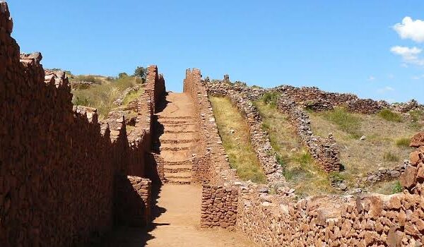
Perched on a rocky ridge more than 4,000 meters above sea level and crowned by two rock formations that resemble horns pointing toward the sky, Waqrapukara is one of the most enigmatic structures in southern Peru. Its name, shape, and location have inspired stories for centuries. The site combines human craftsmanship with dramatic geology in a little-visited corner of Cusco.
What the Name Waqrapukara Means
The name comes from Quechua and translates as “horn-shaped fortress.” It combines waqra (horn) and pukara (fortress or defensive enclosure). The name accurately describes the site’s profile: two twin rock formations rising above the structure and giving it such a distinctive silhouette.
In the Andean worldview, place names often refer to a site’s appearance or function. Here, the choice is clear because these two natural rock towers can be seen from a distance and became part of the memory of those who named the place.
History of the Site
Studies indicate that the site was occupied by the Canchi culture before the expansion of the Tahuantinsuyo. This people controlled the area and took advantage of the ridge’s strategic position, both for ceremonial purposes and to monitor the surrounding territory.
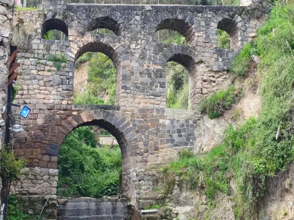
When the Incas arrived, the complex was remodeled and expanded using the fine stonework that characterizes this civilization. The carved stone walls, terraces, and trapezoidal openings show the imperial influence. The construction was adapted to the existing rock, integrating architecture and landscape into a single work.
Function and Meaning
Although the name suggests a defensive purpose, many researchers believe the site primarily served ritual functions. Its isolated and difficult-to-reach location fits better with a sacred space than with a military outpost. It may have combined both roles depending on the period.
In the Andean world, mountains were considered living deities. Waqrapukara rises surrounded by canyons and peaks that formed part of this sacred geography. The construction seems to interact with its surroundings and to be oriented toward natural elements filled with symbolic meaning.
Waqrapukara is located in an isolated area
Architectural Features
The most striking features are the two rock formations that crown the complex. They were not completely carved, but rather partially shaped from the natural bedrock. Between them are enclosures, stairways, and platforms that make use of every projection in the terrain.
The Inca section features well-fitted stone blocks, stepped terraces, and trapezoidal doorways. These details confirm the site’s importance within the imperial system. The combination of carved stone and natural rock gives it a unique character.
Architectural features
Legends of the Site
Stories about Waqrapukara have been passed down from generation to generation. Some connect it with ancient rulers who resisted imperial expansion, while others associate it with rituals dedicated to sacred guardian mountains. Regardless of their historical accuracy, these stories keep the site’s symbolic significance alive among nearby communities.
Why Visit Waqrapukara Today
The same remoteness that kept the site largely forgotten for centuries is now part of its appeal. Visitors find a monument without crowds, surrounded by silence and offering sweeping views over the Apurímac Canyon. The hike to reach it is demanding but rewarding and forms part of the experience of discovering such a secluded place.
If you want to experience it up close, you can take a Waqrapukara tour with Incredible Peru Tours and experience the site at the pace and with the attention it deserves.
Before heading to the fortress of the two horns, it is helpful to know what your body will be facing. The hike has a reputation for being demanding, although its difficulty depends on several factors: the route you choose, the altitude, your fitness level, and the conditions on the day of your visit. Below, each factor is explained so you can arrive prepared.
Overall Difficulty Level
The hike is considered moderately difficult. No technical experience or climbing equipment is required, but a reasonable level of fitness and a willingness to walk for several hours over uneven terrain are necessary. Anyone who regularly does outdoor activities should be able to handle it without major problems; those with a more sedentary lifestyle will find it more demanding.
Factors That Affect the Difficulty
The Altitude
The main challenge is not the incline but the altitude. The route takes place above 4,000 meters, where the air contains less oxygen and any physical effort feels more intense. A slope that would be easy at sea level may require you to stop and catch your breath here. That is why prior acclimatization is just as important as physical preparation.
Altitude of 4,000 meters
Distance and Elevation Gain
Depending on the starting point, the walking section varies in length and elevation change. The route via Sangarará involves a longer hike, with descents and climbs that are especially noticeable on the return. The route via Huayqui shortens the distance and is more manageable for those looking for a less demanding option.
The Type of Terrain
The trail combines flat sections of grassland with rocky uphill stretches. There are no dangerous passages or exposed drop-offs, but the uneven ground requires attention and good footwear. During the rainy season, the terrain becomes slippery and the difficulty increases.
How Long the Hike Takes
Walking time ranges from one to three hours each way, depending on the route and the pace of the group. This does not include stops to rest, hydrate, and take photos. Altogether, the hiking portion can take up a significant part of the day.
Hiking along the route to Waqrapukara
Recommended Physical Preparation
You do not need to be an athlete, but arriving with some training makes a noticeable difference. Going on hikes beforehand, doing cardiovascular exercise in the weeks leading up to the trip, and above all spending a few days acclimatizing to the altitude in Cusco will better prepare your body. Maintaining a steady, unhurried pace is the best way to complete the route with energy.
How to Deal With Altitude Sickness
Altitude sickness can cause symptoms such as headaches, fatigue, or shortness of breath. To reduce the risk, it is best to acclimatize beforehand, stay well hydrated, eat light meals, and avoid alcohol the night before. Many hikers drink coca leaf tea, which is widely used in the region to help cope with the altitude. If symptoms are severe, the safest option is to rest and, if they continue, descend to a lower elevation.
Who Can Do the Hike?
The hike is suitable for adults in good general health who are prepared to walk. It is not recommended for people with heart or respiratory problems without medical approval, or for those who have never been at high altitude without first allowing time to acclimatize. Active children and older adults can complete the hike as long as they move at their own pace and have proper support.
Tips for a More Manageable Hike
Starting early allows you to hike in cooler temperatures and avoid the strong midday sun. Pacing yourself, taking short breaks, and maintaining slow, steady breathing can help you perform better. Having a guide who knows the appropriate pace and the route of the trail makes the experience easier, especially for anyone taking on a high-altitude hike for the first time.
If you prefer to have everything organized, Incredible Peru Tours offers the Waqrapukara excursion with transportation, a guide, and all logistics arranged, so you can focus only on enjoying the journey and the destination.
At the foot of the snow-capped Ausangate, more than 4,300 meters above sea level, a small village holds one of the best-kept secrets of southern Peru. The Pacchanta hot springs welcome hikers looking to rest after exploring the trails surrounding the sacred mountain. These natural hot-water pools are set against a landscape of glacial peaks, grazing alpacas, and clear skies.
Where Are the Pacchanta Hot Springs Located?
Location and Elevation
Pacchanta belongs to the district of Ocongate, in Quispicanchi Province, Cusco Region. The village sits at around 4,300 meters above sea level, right on the slopes of Ausangate. Its location makes it the last inhabited settlement before entering the trekking routes toward the mountain range’s lakes.
Pacchanta in Ocongate
The Village of Pacchanta and Its Surroundings
The village is home to families dedicated to raising camelids and assisting visitors. Adobe houses are scattered around grasslands where alpacas and llamas coexist with passing hikers. From the village, you can enjoy a direct view of the southern face of Ausangate, with its glaciers reflected in the water during the early hours of the day.
How to Get to the Pacchanta Hot Springs
Route from Cusco
The journey begins in Cusco along the paved road leading toward Puerto Maldonado. The route passes through Urcos and then Ocongate, where many travelers make a brief stop. The paved section makes most of the journey easier.
From Tinki to Pacchanta
After Ocongate, you reach Tinki, the town that serves as the gateway to the Ausangate area. From Tinki to Pacchanta, the terrain changes: the road becomes an unpaved track and climbs through an increasingly open landscape. This final section can be traveled by four-wheel-drive vehicle or on foot, depending on the season and road conditions.
Transportation Options and Travel Times
The full trip from Cusco takes between four and five hours by private car. Vans and minibuses operate along the Cusco–Tinki route, and from there travelers can hire local transportation or walk the final section. Those who prefer greater comfort can choose a private service that takes them directly to the village.
What the Hot Spring Pools Are Like
Water Temperature and Mineral Properties
The water rises from underground at a comfortably warm temperature, making it pleasant to stay immersed even when the air outside is cold. Its composition contains minerals that, according to local tradition, help relieve muscle fatigue. For anyone who has just completed a day of hiking, the restorative effect is immediate.
The Pools Facing the Snow-Capped Ausangate
The main attraction of the site is the view. The pools face the glacier, allowing you to relax in the warm water while looking at the snow-covered mountain in the background. The contrast between the steam rising from the pools and the frozen peaks defines the experience.
Available Services and Facilities
The complex has several pools of different sizes, basic changing rooms, and areas where visitors can leave their clothes. The infrastructure is simple, in keeping with the rural character of the site. Some local families offer basic accommodations and meals for those who decide to stay overnight.
The pools facing the snow-capped Ausangate
What to Bring When Visiting the Hot Springs
Recommended Clothing and Accessories
It is a good idea to bring a swimsuit, towel, sandals, and warm clothing for after your bath. A hat and gloves are useful because, as soon as you get out of the water, the temperature can feel much colder. It is also recommended to carry a bottle of water and sunscreen.
High-Altitude Considerations
At this elevation, the body functions with less oxygen, so movements should be slow and steady. Entering and leaving the water calmly helps prevent dizziness. Staying hydrated before and after bathing also helps the body cope better with the altitude.
How Much Does Admission Cost?
Access to the pools has a modest fee that is paid directly at the site and is usually used by the community to maintain the facilities. Accommodation and meal prices are arranged separately with local families. It is a good idea to bring cash in Peruvian soles, as there are no banking services in the area.
Recommended clothing and accessories
Best Time to Visit Pacchanta
Dry Season and Rainy Season
The months from April through October have the clearest days, with a greater chance of seeing the snow-capped mountain without clouds. Rainfall increases between November and March, which can make conditions on the final unpaved road more difficult. For a smoother visit, the dry season is the safest option.
Recommended Times of Day
Early morning offers the clearest views of the glacier and fewer visitors. Late afternoon also has its charm, with warm light illuminating the peaks. If the plan includes trekking, many visitors save their time in the hot springs for the return trip as a reward.
What Else to Do in Pacchanta
Starting Point for the Seven Lakes
The village is the natural starting point for the route to the Seven Lakes of Ausangate, one of the most celebrated circuits in the region. Many visitors combine the hike with a soak in the hot springs on the same day. The proximity of both attractions makes Pacchanta an ideal base.
Hike to the Ausangate Viewpoint
In addition to the route to the lakes, there are short trails leading to viewpoints where Ausangate can be appreciated in all its grandeur. These are accessible options for visitors with less time or energy. The effort is rewarded with sweeping panoramic views of the mountain range.
Recommendations for a Safe Visit
Acclimatize Beforehand
Spending at least two days in Cusco before traveling up to Pacchanta reduces the risk of altitude-related discomfort. The body needs this time to adjust to the lower oxygen levels. Traveling directly from the coast without prior acclimatization is not recommended.
Health Precautions in the Area
Anyone with heart or blood pressure problems should consult a doctor before traveling. It is advisable to carry a basic first-aid kit and, if tolerated, medication for altitude sickness. If any symptoms persist, the safest course of action is to descend to a lower elevation.
Choosing the right travel date can completely change the experience at Waqrapukara. The weather in this highland area makes the difference between a day with clear skies and sharp views of the canyon and a rainy day that makes the hike more difficult. Understanding the seasons helps you plan your visit for the most favorable time.
The Two Seasons of the Year
In this region of southern Peru, the climate is divided into two well-defined seasons: a dry season and a rainy season. There are no four traditional seasons here, but rather a contrast between wet and dry months that determines trekking conditions.
Dry Season
It runs approximately from April to October and includes the best days for visiting the fortress. The sky remains clear much of the time, rainfall is limited, and the trail stays firm. It is the ideal period to appreciate the landscape of the Apurímac Canyon in all its vastness.
Dry season
Rainy Season
It extends from November to March, with frequent rainfall that becomes heavier between January and February. The terrain becomes slippery, visibility decreases, and the hike becomes more difficult. Although the surroundings look greener, the risk of finding muddy trails and cloud-covered scenery makes these months less appealing.
The Best Time for the Hike
The middle months of the dry season, especially from May through September, offer the most stable conditions. Sunny days make the hike easier and provide clear panoramic views of the fortress and its surroundings. Within this period, travelers looking for fewer visitors can choose May or September, at the edges of the high season.
Beginning of the rainy season
Weather During the Day
Cold and Clear Mornings
The early hours are usually very cold, especially during the dry months, when nighttime temperatures can drop below freezing. In return, the morning air is the clearest and offers the best light for viewing the site. Dressing warmly at the start of the day is essential.
Intense Midday Sun
As the morning progresses, the sun becomes stronger and temperatures rise quickly. At this altitude, solar radiation is intense, so sunscreen, a hat, and sunglasses are essential. Dressing in layers makes it easier to adjust to these sudden changes between cold and warmth.
Start your hike early
Recommendations Based on Your Travel Date
Travelers visiting during the dry season should prioritize warm clothing for the mornings and sun protection for the rest of the day. Those who have no choice but to visit during the rainy season should bring waterproof clothing, footwear with good traction, and some flexibility in their itinerary in case the weather requires changes to their plans. In any case, leaving Cusco early helps you make the most of the best hours of daylight and weather.
Considerations About Visitor Numbers
Unlike other destinations in the region, Waqrapukara receives a low number of tourists throughout the year thanks to its remote location. Even so, weekends and holidays during the dry season tend to attract slightly more visitors. For a quieter experience, choosing a weekday during the dry months combines good weather with greater solitude.
If you want to organize your visit during the best time of year, Incredible Peru Tours offers the Waqrapukara Fortress excursion with transportation, a guide, and all logistics arranged so you can enjoy the weather and scenery without worrying about the details.
Getting to Waqrapukara is part of the adventure. The fortress of the two horns is located in a remote corner of the Cusco region, far from the most heavily traveled routes. Reaching it requires combining a road journey with a mountain hike. Below are the routes, travel times, and ways to organize your visit.
Where It Is Located
The site is located in the district of Acomayo, south of Cusco, on a rocky ridge overlooking the Apurímac River canyon. The distance in a straight line is not great, but the rugged terrain requires traveling along winding roads and then continuing on foot. This remote location is precisely what has protected the site from mass tourism.
Apurímac River Canyon.
Access Routes
There are two main access routes, each with a different starting point and a hike of a different duration. The choice depends on how much time you have and your level of physical fitness.
Route via Sangarará
This route starts in the town of Sangarará, in Acomayo Province. From Cusco, you travel by road to this town and then continue along an unpaved road to the point where the hike begins. It is the most commonly used route and can usually be completed in one day.
Route via Huayqui
This route starts from the Huayqui area and offers a shorter hike to the fortress. It reduces the effort required for the walking portion, although vehicle access can be more difficult depending on road conditions. It is a good idea to ask about current conditions before making a decision.
The Road Trip from Cusco
The drive from Cusco to the starting point of the hike takes between three and four hours, depending on the route and road conditions. The first section follows a paved road, while the final section is along an unpaved road. The scenery gradually changes from cultivated valleys to high-Andean landscapes.
Combining both sections, the total overland journey takes around three to four hours each way. The hike and the time spent at the site must also be added, so the visit is usually planned as a long day that begins before dawn.
The Final Hike
No vehicle can reach the base of the monument, so the final section must be completed on foot. Depending on the route, the hike takes between one and three hours each way. The trail crosses high-altitude grasslands, with uphill and downhill sections that require good stamina, until reaching the open area from where the fortress comes into view.
Ways to Organize Your Visit
On Your Own
It is possible to visit independently by combining public transportation to Acomayo with local transportation to the beginning of the trail. This option requires planning, plenty of time, and some experience traveling through rural areas. Signage is limited, and services along the way are scarce.
With a Specialized Tour Operator
The most convenient and safest alternative is to book the trip with a tour operator that takes care of everything. Incredible Peru Tours organizes a Waqrapukara Fortress Hike with transportation from Cusco, a professional guide, and logistics handled from start to finish. This avoids the difficulty of coordinating transportation in areas where public transit is irregular and provides the guidance of someone who knows the history of the site and the terrain. For such a remote destination, relying on an experienced operator can make the difference between a smooth day and one filled with unexpected problems.
Recommendations for the Journey
It is best to leave Cusco very early to make the most of the daylight and return before nightfall. Bringing hiking shoes, water, snacks, sun protection, and warm clothing for the high-altitude conditions is essential. Since the route takes place above 4,000 meters, acclimatizing in Cusco during the previous days helps you handle the hike more comfortably and avoid unnecessary difficulties.
The Seven Lagoons of Ausangate circuit is not a single lagoon seen from different angles: there are seven different bodies of water, each with its own Quechua name, color, and history. Knowing them before you go gives the hike a different meaning, because you stop seeing “beautiful lagoons” and start recognizing each one and understanding why it has its name.
How many lagoons are visited
As its name suggests, the circuit goes through seven lagoons. They were all formed by the melting snow and ice of Ausangate Mountain and are fed by its glaciers, which explains why their waters remain cold all year and why their colors depend so much on the minerals in the terrain as well as the daylight.
One clarification: the names and the order may vary slightly depending on the operator and the guide. Some sources include lagoons such as Yanacocha or Oqecocha instead of others, but the most commonly cited and recognized group consists of Pucacocha, Patacocha, Alqacocha, Qomercocha, Orco Otorongo, China Otorongo, and Azulcocha.
General route
The circuit is circular: it begins and ends in the community of Pacchanta, and goes around the surroundings of Ausangate Mountain, passing by the seven lagoons in sequence. At first, the trail runs almost flat over puna terrain and gravel, and as you gain elevation, the bodies of water begin appearing one after another.
Along the route, you are accompanied by alpacas, llamas and, with some luck, a condor flying over the peaks. Each lagoon offers a different view of the mountain and the Vilcanota mountain range, so the hike feels more like a succession of natural viewpoints than a monotonous stretch.
First lagoon
The first is usually Pucacocha, whose name in Quechua means “red lagoon.” It is also known as the chocolate lagoon because of the reddish or brownish tone of its waters, caused by the minerals in the terrain. Its contrast with the landscape makes it striking from the very beginning.
For many local communities, Pucacocha also has sacred value, associated with life and the water that flows down from Ausangate. It is the gateway to the circuit and the first stop where hikers begin to understand what this route is all about.
Second lagoon
Next comes Patacocha, a lagoon whose name is related to the idea of “above” or “upper area,” because of the altitude where it is located, close to the mountain. It is one of the highest on the circuit, which is why Ausangate can be seen more clearly from its shores than from the first lagoon.
Its waters stand out for being clearer and more transparent. Because it is somewhat hidden behind the terrain formations, sometimes you do not see it until you are almost right next to it, which makes it a small surprise along the route.
Third lagoon
The third is Alqacocha. Sources translate its name in different ways: some as “two-colored lagoon” because of its chromatic duality, others with different references. It is located in a high area of the circuit, where the cold begins to feel stronger.
It is one of the most serene lagoons on the route, with an almost perfect reflection of the mountains in its waters when the day is calm. Because of that peaceful atmosphere, many hikers use it as a place to rest and contemplate before continuing.
Fourth lagoon
Then comes Qomercocha, which in Quechua means “green lagoon.” The name fits it well: its waters display an intense turquoise or emerald color, the result of the minerals and algae present in it. It is located around 4,600 to 4,666 m above sea level.
It is one of the favorites on the route because it offers one of the best views of the entire area, with the mountain in the background and the green water in the foreground. For many photographers, it is one of the lagoons that best captures the magic of the circuit.
Fifth lagoon
The fifth is Orco Otorongo, whose name refers to the otorongo, the jaguar of the jungle, in its “male” version (orco). It is said that, when seen from above, its outline resembles the silhouette or spotted coat of this feline, a sacred animal in the Andean worldview.
It is a lagoon full of symbolism. Together with the next one, it forms a pair that represents Andean duality, a concept that the guide usually explains at this point along the route and that adds a cultural layer to the beauty of the landscape.
Sixth lagoon
Very close to the previous one is China Otorongo, the “female otorongo” (china means “female” in Quechua). It complements Orco Otorongo and together they embody the Andean idea of duality: masculine and feminine, two sides of the same element.
According to local tradition, its waters are described as somewhat darker or more turbulent than those of its male counterpart. Surrounded by rock formations, it has a mystical atmosphere that sets it apart within the circuit.
Seventh lagoon
The route usually ends with Azulcocha, whose name means “blue lagoon.” It is known for the intense, deep blue tone of its waters, which reflect the Andean sky, and many consider it the deepest and one of the most photographed of all.
Because it is often the last lagoon on the circuit, it serves as the finishing touch to the route: a good place to stop, breathe, and take in the view for a moment before beginning the descent back to Pacchanta. It is worth remembering that, depending on the direction in which the guide does the circuit, Azulcocha may also be one of the first to appear.
Characteristics and colors
The main attraction of the circuit is that no lagoon looks like the previous one. Pucacocha has reddish or chocolate tones; Qomercocha has emerald green tones; Azulcocha has deep blue tones; Patacocha stands out for its transparency. That palette is no coincidence: it depends on the dissolved minerals, the depth of each lagoon, and the way the light hits them depending on the time of day.
That same factor causes the color to change throughout the day and with the weather. A lagoon that looks bright turquoise in the mid-morning sun may appear more muted under a cloudy sky. That is why it is best to arrive early, when the light favors the most vivid colors.
Azulcocha Lagoon
Order in which they are visited
The order is not fixed. Since it is a circular circuit, the guide can follow it in either direction depending on the weather conditions, the state of the terrain, and the time, always trying to take advantage of the best light at the main viewpoint. That is why the same lagoon may appear as “first” in one blog and “last” in another.
What remains constant is that the route begins and ends in Pacchanta and passes by all seven along a trail without complicated intersections. Rather than memorizing an exact sequence, it is better to follow the guide and enjoy each lagoon as it appears.
Which lagoon is the most impressive
For lovers of vibrant color, Qomercocha with its emerald green usually takes the prize. For those looking for the deepest blue, Azulcocha is the favorite. And for those who appreciate dramatic contrast, Pucacocha with its reddish tone is hard to beat.
The Otorongo lagoons, for their part, stand out not so much because of their color but because of the history and symbolism they carry. In practice, the “most impressive” one ends up being whichever one you see with the best light on the day of your visit.
Azulcocha
What makes these lagoons unique
What sets this circuit apart is the combination of three things: the variety of colors within a relatively small area, the constant backdrop of Ausangate Mountain, and the cultural significance of each name. They are not just lagoons: they are part of the Andean worldview, connected to the figure of Apu Ausangate as the protector of water and the land.
Added to that is the living puna environment, with alpacas, llamas, and the community of Pacchanta, which manages and takes care of the circuit. Walking among these seven lagoons means traveling through a natural landscape and, at the same time, a territory with centuries of meaning for the people who live at the foot of the mountain.
Seven Lagoons with llamas
Experience the route with Incredible Peru Tours
Knowing the names is one thing; exploring the seven lagoons with someone who knows how to read them is another. At Incredible Peru Tours, we take you through the complete circuit with guides who know each lagoon, its meaning, and the best spots to appreciate and photograph them with Ausangate in the background.
We take care of all the logistics, from pickup at your hotel to the Pacchanta hot springs at the end of the day, so you only have to focus on walking and enjoying the experience. If you want to experience this adventure without missing any detail, check out our 7 Lagoons of Ausangate tour and we will organize your excursion.
Frequently asked questions
How many lagoons are visited on the Ausangate route? Seven, all formed by the melting snow and ice of Ausangate Mountain. The most commonly cited are Pucacocha, Patacocha, Alqacocha, Qomercocha, Orco Otorongo, China Otorongo, and Azulcocha.
Why do they have different colors? Because of the minerals dissolved in each lagoon, their depth, and the way the light hits them depending on the time of day. The color can change between a sunny morning and a cloudy afternoon.
In what order are they visited? There is no fixed order. It is a circular circuit that the guide follows in one direction or the other depending on the weather and the light, always beginning and ending in Pacchanta.
What do their names mean? They are Quechua names related to color or shape: Pucacocha (red), Qomercocha (green), Azulcocha (blue), and the Otorongo lagoons because of their connection to the jaguar. Some meanings vary depending on the source.
Which lagoon is the most beautiful? It is subjective. Qomercocha stands out for its green color, Azulcocha for its deep blue, and Pucacocha for its reddish tone. The best one is usually whichever you see with the best light that day.
Can you swim in them? No. They are very cold glacial lagoons and have cultural value for the community, so the circuit is only for walking and enjoying the scenery.