
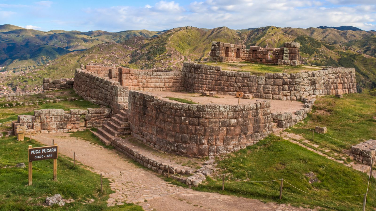
Puka Pukara is an Inca archaeological complex located northeast of the city of Cusco, in an elevated position along the road that leads to Pisac. It ranks among the main archaeological sites near the city because of its connection to the ancient access routes into the Inca capital, its stone construction, and its proximity to Tambomachay. It is associated with surveillance and control functions, though its use may have been broader. To enter, you need the Cusco Tourist Ticket covering the archaeological parks, and it’s worth confirming its validity and conditions before you travel.
During the visit you can walk among walls, terraces, enclosures, entryways, and open spaces spread across a hillside. The tour is usually combined with Tambomachay, Qenqo, and Sacsayhuaman, whether on a City Tour, in a private vehicle, or in a tourist shuttle.
What is Puka Pukara?
Puka Pukara is an Inca archaeological complex on the outskirts of Cusco. Its position on high ground gave it a wide view of the nearby roads and ravines, a feature that explains why it is linked to the surveillance of one of the entrances to the ancient capital of the Tahuantinsuyo.
Although it is popularly known as a fortress, the site should not be understood as a purely military structure. Its walls, terraces, enclosures, stairways, and paths suggest it may have served functions tied to control, administration, rest, and support for the activities that took place in this part of Cusco.
Meaning of the name “Red Fortress”
The name Puka Pukara comes from Quechua. “Puka” relates to the color red and “pukara” to a fortress or fortified place. That is why the most widespread translation is “Red Fortress.”
This name is usually associated with the reddish tone that some of the complex’s stones take on at certain hours of the day, especially when they catch direct sunlight. The color can also shift depending on humidity, the season, and sky conditions, so it isn’t always visible with the same intensity.
Location of Puka Pukara near Cusco
Puka Pukara sits northeast of the city of Cusco, right along the highway heading toward Pisac and the Sacred Valley. From the Plaza de Armas, the drive takes roughly 25 to 40 minutes, depending on traffic, the type of transportation, and your exact starting point.
The complex is part of the circuit of archaeological parks near Cusco. Its location makes it easy to link the visit with Tambomachay, just a few minutes away, along with Qenqo and Sacsayhuaman. For that reason, many people tour it during their first afternoon in the city.
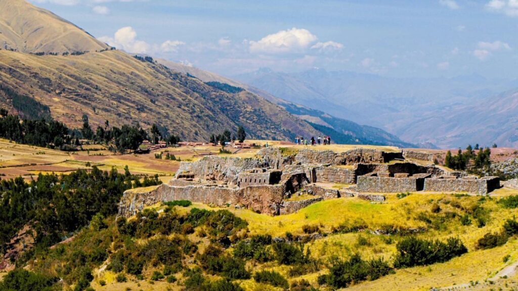
The relationship between Puka Pukara and Tambomachay
Puka Pukara is very close to Tambomachay, so both sites are typically visited on the same outing. The short distance between the two complexes makes them practical to combine even when you travel on your own by taxi or public transportation.
Some interpretations suggest that Puka Pukara may have supported the activities carried out at Tambomachay through control, surveillance, or temporary lodging. However, these proposals have not been definitively confirmed, so they should be presented as archaeological hypotheses rather than proven facts.
History of Puka Pukara
Puka Pukara is Inca in origin and formed part of the territory surrounding the ancient imperial capital. Its construction responded to the need to organize the entrances to Cusco and take advantage of high points from which the immediate surroundings could be observed.
The available information makes its strategic value clear, but it does not settle every detail about its occupation and day-to-day use. Historical sources and archaeological evidence have produced different interpretations, so a responsible visit should distinguish between what is visible on the ground and the theories about its function.
Origin of the Inca archaeological complex
Puka Pukara was built during the Inca period, taking advantage of the mountain’s natural shape. Rather than leveling the hillside completely, the builders adapted walls, terraces, and enclosures to its slopes, a common practice in the works developed around Cusco.
The location and characteristics of the site connect it to territorial control and to the activities carried out at the entrances to the city. Its structures show varying levels of stonework and a layout designed to make the most of both the incline and the visibility across the landscape.
Importance within the access roads to Cusco
Puka Pukara sits beside an ancient route that connected Cusco with territories to the east. This position made it possible to watch the movement of people, animals, and goods traveling between the Inca capital and other parts of its territory.
From the complex, stretches of the road could be monitored and one of the entrances to the city controlled. This geographic advantage supports the idea that the place had a function tied to managing circulation, though on its own it doesn’t reveal how the site was internally organized or who occupied it permanently.
What was Puka Pukara used for?
There is no single, fully proven explanation for Puka Pukara’s function. The most widely accepted interpretations link it to surveillance, traffic control, administrative support, and temporary rest for people traveling along the nearby route.
Its elevated position, the presence of walls, and the layout of its enclosures explain why it was described for so long as primarily a fortress. Even so, the interior sectors and open spaces point to a more varied occupation than that of a purely defensive outpost.
Control and surveillance function
Puka Pukara’s position allowed people to watch the road and several areas near Cusco. From this point there was a favorable view of anyone entering or leaving along the route, a useful condition for monitoring the movement of travelers and groups tied to the Inca administration.
It has also been suggested that the transport of goods and pack animals could be supervised from there. This possibility rests on its strategic location, but it should not be taken as proof of a specific system of tolls, record-keeping, or inspection, since the details of such activities are not known with certainty.
Military and administrative function
Puka Pukara has been described as a military structure because of its walls, its elevation, and its proximity to an access road. These traits would have made it possible to respond to situations of territorial control or to protect the passage into the city.
At the same time, the complex may have handled administrative, logistical, or travel-organization tasks. Presenting it only as a fortress narrows how the site can be read, since its enclosures and terraces allow for complementary uses tied to transit and to the management of this area near Cusco.
Lodging for the Inca’s retinue
One of the best-known theories holds that Puka Pukara served as a resting place for soldiers, attendants, and members of the Inca’s retinue. This proposal is connected to the closeness of Tambomachay, where activities tied to water and the natural surroundings would have taken place.
The idea is that part of the retinue could stay at Puka Pukara while the Inca and other high-ranking figures carried out activities at the neighboring complex. It’s an interpretation widely repeated on tours, but it has not been conclusively demonstrated by direct historical documentation.
Architecture of Puka Pukara
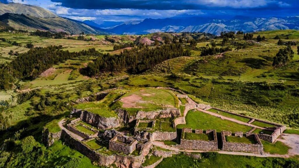
Puka Pukara’s architecture adapts to the mountain slope through stepped construction. The site combines stone, terraces, retaining walls, enclosures, and circulation areas that take advantage of the uneven ground.
Walking through the site, you notice different levels and changes in height. This layout didn’t just solve the challenges of the hillside; it also organized the entryways, open areas, and interior spaces of the complex.
Walls and terraces built on the mountainside
The complex is made up of walls and terraces raised to follow the irregular shape of the terrain. The platforms bring order to the hillside and create more stable surfaces for movement and for building enclosures.
These structures show how the Incas adapted their work to the landscape without separating construction from topography. At Puka Pukara you can see sectors with different stone finishes, which may reflect differences in function, location, or building process.
Small plaza, rooms, and interior enclosures
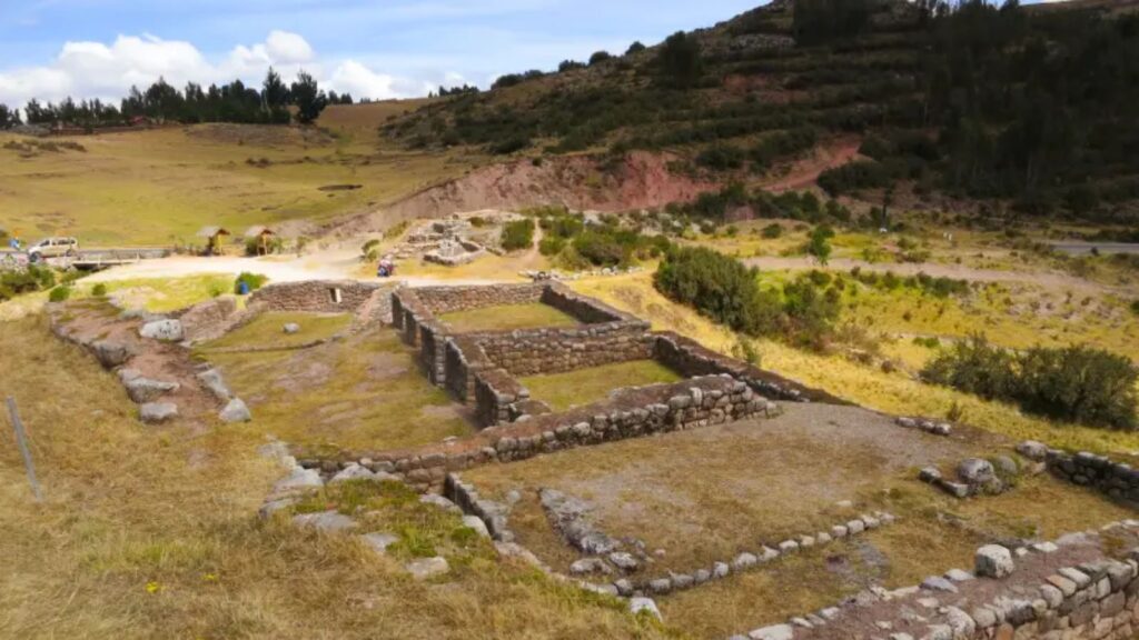
Along the route you’ll see open spaces resembling small plazas, along with rooms, passageways, and interior enclosures. Some spaces still clearly preserve their walls, while others are recognizable from the base of the structures and the arrangement of the stones.
The layout of these sectors supports the possibility that Puka Pukara served several functions. The presence of circulation areas, enclosed spaces, and open areas is consistent with activities of control, temporary stay, and organization of people, even though no single enclosure can be assigned a specific use with full certainty.
The double-jamb doorway
A double-jamb doorway is an entrance formed by two stepped frames or recesses around an opening. This architectural device appears in various Inca constructions and usually indicates that the entrance led to a space of some importance within the site.
At Puka Pukara you can see this type of entrance in one of its sectors. Its presence helps you recognize the range of building solutions used in the complex, though on its own it doesn’t define with certainty the exact function of the enclosure it belonged to.
The fountains at the front of the site
At the front of the complex there are structures related to channeling or releasing water. These elements are part of the site’s organization and show that water management was also considered during construction.
There isn’t enough evidence to attribute a specific ceremonial function to them. During your visit, the best approach is to observe how they relate to the walls and changes in ground level, without assuming that every water structure within an Inca site necessarily had a ritual use.
What to see during your visit to Puka Pukara
A visit to Puka Pukara lets you take in a compact set of Inca constructions spread across a hillside. The walk is short compared with other archaeological parks around Cusco, but it rewards you with a variety of architectural elements and with views over the historic route into the city.
It’s worth walking slowly, pausing at the changes in level, and looking at how the walls, terraces, and surroundings relate to one another. That helps you understand why this spot was useful for controlling movement through the area.
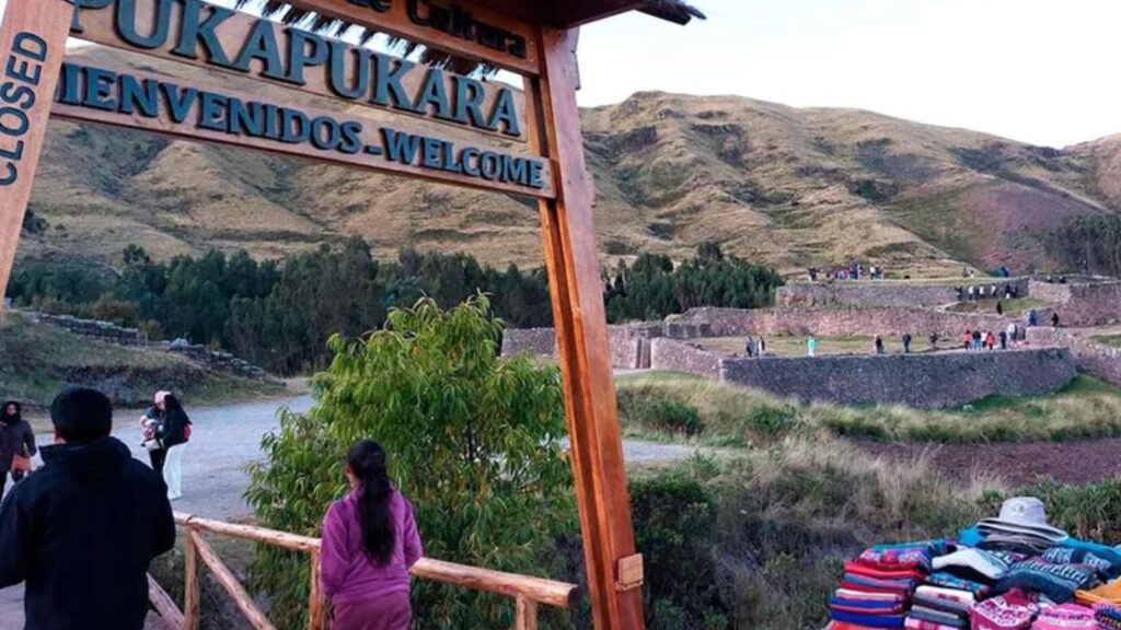
Main archaeological structures
Among the most visible elements of Puka Pukara are the outer walls, terraces, stairways, enclosures, passageways, small plazas, and entryways. The walls follow the shape of the slope, while the terraces organize the levels of the terrain.
The stairways and passageways connect the different sectors of the complex. In the interior enclosures you can appreciate stone walls and doorways, while the open areas let you make out the overall layout of the site without attributing functions that archaeological research has not confirmed.
Views of the Andean landscape and the ancient road to Cusco
From Puka Pukara you can see mountains, ravines, rural areas, and the road that connects Cusco with Pisac. These views help you grasp how much visual range the place offered to those who controlled passage along this route.
The surroundings help explain why this site was chosen. Rather than looking only at stone walls, it’s worth taking in the orientation of the complex and the natural corridors around it, because that’s where its connection to one of the access routes into the city of Cusco becomes clear.
How to visit Puka Pukara
You can visit Puka Pukara from Cusco by taxi, public transportation, tourist vehicle, or on a City Tour that includes the nearby archaeological parks. The most convenient option for a first visit is usually an organized tour, since it normally links the complex with Sacsayhuaman, Qenqo, and Tambomachay.
If you prefer to go on your own, it’s a good idea to check road conditions, boarding points, visiting hours, and the validity of the Tourist Ticket before heading out. The weather can change quickly in this area, especially during the rainy season.
How to get there from the city of Cusco
The most direct option is to take a taxi from downtown Cusco to Puka Pukara. Before getting in, agree on the price, ask whether the driver can wait during your visit, and confirm whether the service will include a stop at Tambomachay or other nearby sites.
There is also public transportation and there are vehicles running along the route toward Pisac, though boarding points and routes can vary. City Tours simplify the logistics, but they give you less free time at each park. Walking from downtown Cusco is more demanding because of the distance, the inclines, and the altitude, so it usually isn’t the best choice for travelers who have just arrived.
Admission and access with the Cusco Tourist Ticket
Puka Pukara is one of the attractions included in the Cusco Tourist Ticket. To visit the nearby archaeological parks, travelers generally use the partial ticket for this circuit, while the full ticket covers a wider selection of sites, museums, and cultural attractions.
Prices, validity periods, terms of use, and included sites can change. Before buying, check the official COSITUC information to confirm which ticket suits your itinerary. Avoid buying tickets from resellers or assuming that a partial ticket works for every circuit in Cusco.
Tips for touring the site
Bring your ID and your Cusco Tourist Ticket, since they may be requested at the entrance. It’s also worth carrying water, sunscreen, a hat, layered clothing, and shoes with good grip, since there are uneven surfaces and changes in level.
During the rainy season, add a waterproof layer and protect your electronics. Respect the marked trails, the barriers, and the restricted areas. Don’t climb on the walls or wander off the permitted paths, both for your safety and for the preservation of the archaeological complex.


