
The Inca Trail is not just a mountain trail that ends at Machu Picchu. It is an archaeological corridor in itself, lined with sites built by the Inca Empire that most travelers walk past without stopping to understand. Llaqtapata, Sayacmarca, and Wiñay Wayna are three of those sites: different in function, scale, and state of preservation, but equally valuable for understanding what the Inca Trail was before it became a tourist route.
The Inca Trail as an archaeological corridor
When archaeologists talk about the Inca Trail, they are not referring only to the stone path connecting kilometer 82 with the Sun Gate. They are referring to an imperial infrastructure system that included tambos for the rest and resupply of the chasquis, administrative and ceremonial centers, high-production agricultural terraces, and territorial control enclaves distributed along the entire route.
The intermediate archaeological sites of the Classic Inca Trail are not minor ruins or extensions of Machu Picchu. They are part of the same planned network that turned this stretch of mountain into one of the most strategic corridors of the Tahuantinsuyo. Getting to know them in detail transforms the trekking experience: instead of walking toward a destination, you walk through a territory with its own history in every mile.
Llaqtapata: the first archaeological site on the route
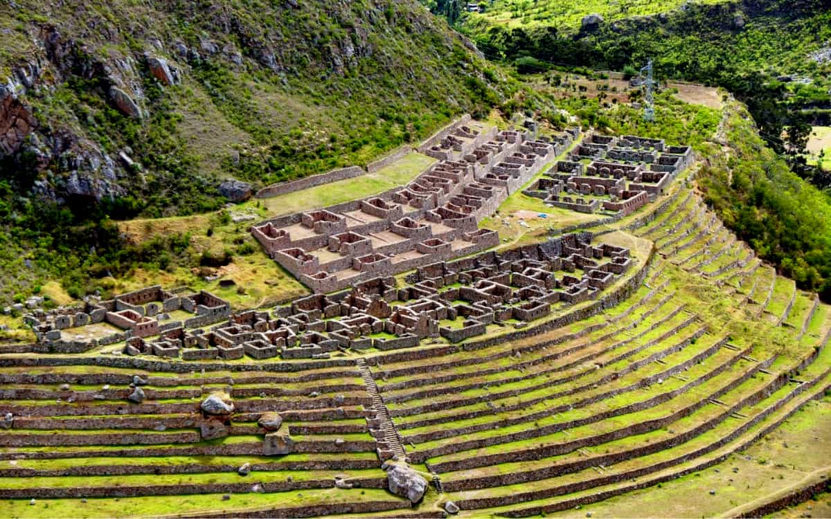
Llaqtapata is the first significant archaeological site encountered by hikers on the Classic Inca Trail, located about three hours on foot from kilometer 82. Its name in Quechua literally means “place on the slope” or “town on the hillside,” an accurate description of its position on the slopes descending toward the Cusichaca River.
Location and architectural features
The site is located at approximately 2,700 meters above sea level and consists of a group of rectangular structures laid out on artificial terraces that control the slope of the land. The preserved structures include kallankas, large rectangular halls for communal or ceremonial use, storage buildings or qollqas, and open spaces that likely served as gathering plazas. The masonry combines rough stone with more refined elements in the areas of greater functional importance.
There is also a second site with the same name, located at a higher elevation with direct views of Machu Picchu from the opposite side of the usual perspective. This second Llaqtapata, accessible from the Salkantay Trek, offers a view of the citadel that very few travelers know about and that researchers use to understand the visual and astronomical relationship between both complexes.
Historical function and relationship to the trail
Researchers mainly interpret Llaqtapata as a tambo, meaning a resting point, storage center, and redistribution hub for resources along the imperial road. Tambos were essential logistical nodes in the Inca administrative system: food, clothing, and tools were stored there for state workers, marching armies, and messengers in the chasqui system.
Its location in the first section of the Inca Trail, a day’s walk from the starting point at Piscacucho, is consistent with this role of supporting the flow of people and resources moving through the corridor toward the Machu Picchu region. Some archaeologists also point to a possible ceremonial component related to water worship, since the site is near water sources and well-preserved irrigation canals.
Sayacmarca: the inaccessible citadel on the cliff
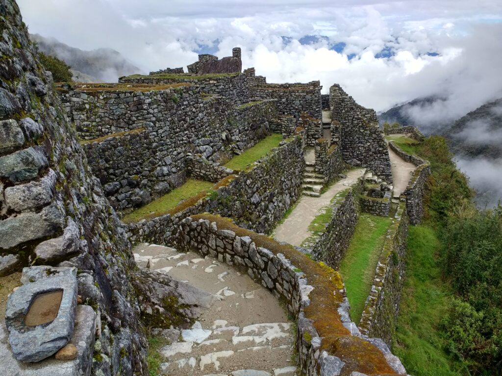
Of all the intermediate sites on the Inca Trail, Sayacmarca is the one that makes the strongest visual impression on hikers. Its Quechua name can be translated as “inaccessible town” or “dominant place,” and the description is completely accurate: the site sits on a rocky outcrop in the middle of a cliff, with sheer drops on three sides and access possible only by a narrow staircase carved into the stone.
Location, altitude, and access
Sayacmarca sits at approximately 3,580 meters above sea level, in the second section of the Inca Trail between the first and second mountain passes. Access from the main trail is by a staircase of several dozen steps carved directly into the rock, bordered by a steep drop that makes the entrance as physical as it is visually striking. From the top of the site, the views over the Aobamba and Urubamba valleys are extraordinary on clear days.
Architectural features of the site
The Sayacmarca complex is relatively compact because the space available on the rock is limited by the natural geometry of the cliff. The structures include semicircular and rectangular enclosures with trapezoidal niches in the interior walls, ritual water fountains with channels carved into stone, a central plaza, and several terraces adapted to the uneven terrain. The quality of the masonry is noticeably superior to that of Llaqtapata, with more precise stonework in the main enclosures.
One of the most studied features of Sayacmarca is its system of water channels and fountains. Water was a central element in Inca cosmology and architecture: it not only served a practical purpose for supply, but also had a deep ritual meaning associated with fertility, purification, and communication with water deities. The stepped fountains of Sayacmarca are one of the best expressions of this integration of hydraulic engineering and religious symbolism on the entire Inca Trail.
Interpretation and function of the site
The exact function of Sayacmarca has been debated by archaeologists since explorer Paul Fejos documented it in the 1940s. The most accepted hypothesis today is that it was a ceremonial and administrative center tied to the control of the surrounding territory and possibly to astronomical rituals. Its elevated position with visibility over wide stretches of the Andean landscape and the presence of high-quality structures point to elite use, possibly related to priests or administrators of the Inca state.
The difficulty of access was not a problem for the Incas, but a strategic advantage: the site was practically impregnable from any direction other than the controlled entry trail. This, combined with its ceremonial role, makes it one of the clearest examples of how the Incas integrated defense, territorial control, and religious expression into a single architectural complex.
Wiñay Wayna: the most impressive site on the Inca Trail
Wiñay Wayna is the most complex, best preserved, and most impressive archaeological site found along the Inca Trail, with the exception of Machu Picchu itself. Its name in Quechua means “forever young” or “eternally young,” a reference to the pink Epidendrum secundum orchids that bloom year-round on the slopes where the complex stands.
Location and context within the route
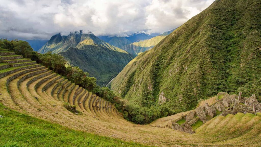
The site is located at 2,650 meters above sea level, in the final section of the Inca Trail before reaching the Sun Gate, and is nestled on a steep cloud forest slope overlooking the Urubamba River canyon. It is the last major archaeological site before Machu Picchu and the one hikers visit on the afternoon of the third day or the early morning of the fourth, depending on the agency’s itinerary. Its physical and visual proximity to Machu Picchu is not accidental: both complexes were part of the same architectural and ritual system planned from Cusco.
Architectural description of the complex
Wiñay Wayna is divided into two major sectors connected by a central staircase: the upper sector, with residential and ceremonial structures of higher rank, and the lower sector, dominated by an impressive series of stepped agricultural terraces descending the slope to the edge of the cliff. Between both sectors are ritual water fountains, one of the most elaborate on the Inca Trail, with ten stepped spouts descending symmetrically between the structures.
The structures in the upper sector have trapezoidal windows and doorways characteristic of imperial Inca architecture, with interior niches that likely held offerings or representations of deities. In some sections, the walls still preserve the original mortar and surface finish, allowing visitors to appreciate the quality of Inca stonework. The integration of the complex with the natural cloud forest landscape, with constant humidity and vegetation surrounding the structures, adds an aesthetic dimension to the archaeological experience that few sites in the world can match.
Function and historical interpretation
Researchers interpret Wiñay Wayna as a ceremonial and highly productive agricultural center directly linked to Machu Picchu. The terraces in the lower sector did not only serve to produce food on a steep mountainside, but also fulfilled a ritual function: agricultural production in the most important Inca sites was not only economic, it was also an offering to the deities and an expression of the state’s power over nature.
The presence of the stepped water fountains reinforces the ceremonial interpretation of the site. In Andean cosmology, water descending from the heights carries sacred energy, and the channels and fountains that direct and distribute it are acts of religious architecture as much as hydraulic engineering. Wiñay Wayna is possibly the most complete example of this conception of water along the entire Inca Trail route.
Other archaeological sites on the Inca Trail
In addition to the three main sites, the Inca Trail includes other archaeological complexes that enrich the journey and complete the picture of the imperial corridor.
Runkurakay, Phuyupatamarca, and the Sun Gate
Runkurakay, located near the second mountain pass at 3,760 meters, is a semicircular tambo overlooking the Urubamba Valley. Its unusual shape for Inca architecture has sparked debate among archaeologists, although the most widespread hypothesis identifies it as a checkpoint and resting place in the highest section of the route.
Phuyupatamarca, whose name means “town above the clouds,” sits at 3,600 meters and offers some of the widest views on the entire Inca Trail when the weather allows. Its ceremonial water fountains are comparable in quality to those of Wiñay Wayna, and its position on the mountain ridge gives it an imposing visual presence over the surrounding landscape.
The Sun Gate, Inti Punku, is not a large-scale archaeological site but rather a control and access structure to the Machu Picchu complex from the imperial road. Its importance lies in the view it offers over the citadel at sunrise on the fourth day, a moment that hikers consistently describe as one of the most emotional parts of the entire trip to Peru.
How to make the most of visiting these sites
Most groups hiking the Inca Trail pass through these sites with brief stops, sometimes lasting only ten or fifteen minutes. With the right guide and some preparation ahead of time, the experience can be significantly richer.
The importance of a guide specialized in Andean archaeology
The difference between seeing a group of stone walls and understanding their function, symbolism, and place within the Inca imperial system depends almost entirely on the quality of the guide. A guide trained in Andean archaeology turns each site into a living explanation of how the Tahuantinsuyo worked: how labor was organized, how resources were distributed, and how religion, agriculture, and administration were integrated into a single built space.
When booking your Inca Trail trek, ask specifically about the archaeological training and experience of the assigned guide. Not all guides certified for the Inca Trail have the same level of knowledge about the intermediate sites: some specialize in trek logistics and spend little time on historical interpretation. For a traveler interested in the archaeological content, this is one of the most important selection criteria.
Recommendations for enjoying each site along the route
Bring a notebook or use your phone to write down the names and functions of each site while the guide explains: by the end of the trek, the details of Llaqtapata and Sayacmarca tend to blend together in memory with the accumulated fatigue. Set aside extra time at Wiñay Wayna beyond the minimum allowed in the itinerary: it is the site most deserving of a slower visit and the one that rewards travelers the most when they stop to observe the details of the masonry and water fountains. If the group reaches Wiñay Wayna at sunset on the third day, the light in the cloud forest is especially photogenic.
At Sayacmarca, be careful on the climb up the staircase carved into the rock, especially if it has rained: the steps may be wet and slippery. Trekking poles are useful in this section, although some hikers prefer to put them away to keep their hands free during the climb.
Book your Inca Trail with Incredible Peru Tours
At Incredible Peru Tours, we operate the Classic Inca Trail with guides specialized in Andean history and archaeology, full logistics from Cusco, and small groups that allow enough time at each site to truly enjoy it. We handle the official Ministry of Culture permits with the required advance notice and design itineraries that give proper importance to the intermediate sites, not just the final destination.
If you want to hike the Inca Trail with the depth it deserves, contact us with your travel dates and we will prepare a personalized proposal for you.


